
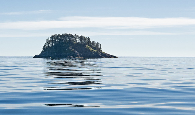
This picture was taken a couple of years ago when we were visiting the abandoned Haida villages in Haida Gwaii, formerly the Queen Charlotte Islands, of the north-west coast of mainland British Columbia.
The reason for the post is that this is the area that was hit by a 7.7 magnitude earthquake yesterday. These islands lie just north of the Queen Charlotte Fault, which is Canada's version of the San Andreas Fault. This was the largest earthquake to hit Canada in over 60 years. So far as I can tell, this is quite close to the earthquake epicentre.
This shot is pretty well due west, looking toward the mainland, and is a bit unusual, as this part of the world is usually rather cloudy and rainy with high waves. We had to take shelter in a small cover the previous day because of 2-3m / 6-10ft waves, making it difficult to head back to Camp Moresby. We are heading north on an old converted lumber camp supply boat. Graham Island is right behind us. The water was almost as smooth as glass. It's hard to believe that this is Hecate Strait, part of the North Pacific.
The other reason I wanted to post this image is that there are a number of people that complain about lens quality and how it has a negative impact on their image quality. This picture was taken with a cheap f/3.5-5.6 18-55mm kit lens.
 Helpful Posts: 0
Results 1 to 2 of 2
Thread: Morning on Hecate Strait
-
29th October 2012, 12:41 AM #1Moderator


- Join Date
- Mar 2012
- Location
- Ottawa, Canada
- Posts
- 22,497
- Real Name
- Manfred Mueller
Morning on Hecate Strait
Last edited by Manfred M; 10th November 2012 at 08:20 PM.
-
29th October 2012, 10:30 AM #2

- Join Date
- Jul 2012
- Location
- Cheshire, England
- Posts
- 3,668
- Real Name
- Dave
Re: Morning on Hecate Strait
Sorry Manfred we can't see the pic- saya it's unavailable

 Reply With Quote